Open Data Catalogue
TERMS AND CONDITIONS OF USE:
GEOGRAPHIC INFORMATION SYSTEM DATABASE
(YOU MUST PRESS THE "Accept" BUTTON TO ACCEPT THE TERMS)
The data available from this web page is provided as a public service by the City of Chilliwack (the "City") on the following terms:
- In consideration for the City granting access to this data, the person accessing the data (the "User") must agree to and accept these Terms of Use.
- The data is supplied on an as is, where is basis. The City assumes no obligation or liability for the use of this data by any person and makes no representations or promises regarding the completeness or accuracy of the data or its fitness for a particular purpose. This data represents a one-time capture of information as it exists at the time the information is posted to this website and does not necessarily include the ongoing updates or corrections to the source databases maintained by the City or other agencies.
- All right, title and interest (including all copyright, patent, and other intellectual property rights) remain vested in the City at all times. The City's original copyright and other proprietary notices must remain intact at all times.
- The User agrees to indemnify and hold harmless the City and its officials, employees and agents from and against all losses, claims, demands, actions, payments, expenses, costs, suits, and damages (including any damages that are direct, indirect, incidental, special or consequential), whether or not caused by any form of negligence of the City, or its officials, employees or agents, which are incurred by the City and would not or could not have been incurred but for the User's use of the data or the User's breach of these Terms of Use.
- Where there is a conflict between the information on this web site and information contained in any other records of the City or documents that may be prepared by or delivered to the City, the City reserves the right to rely in all cases upon the record which it considers to be the most accurate and complete.
- Failure of the User to comply with these Terms of Use will result in the automatic termination of the User's rights to access to this service.
- These Terms of Use are governed by the laws of British Columbia, Canada. If any part of these Terms of Use is found to be unenforceable, then that part will be severed so that the remainder of these Terms of Use can continue to be enforceable.
Click the "Accept" button to confirm that you have read the disclaimer and understand and accept the terms of use.
Or, click the "Decline" button to be returned to the City of Chilliwack's website.
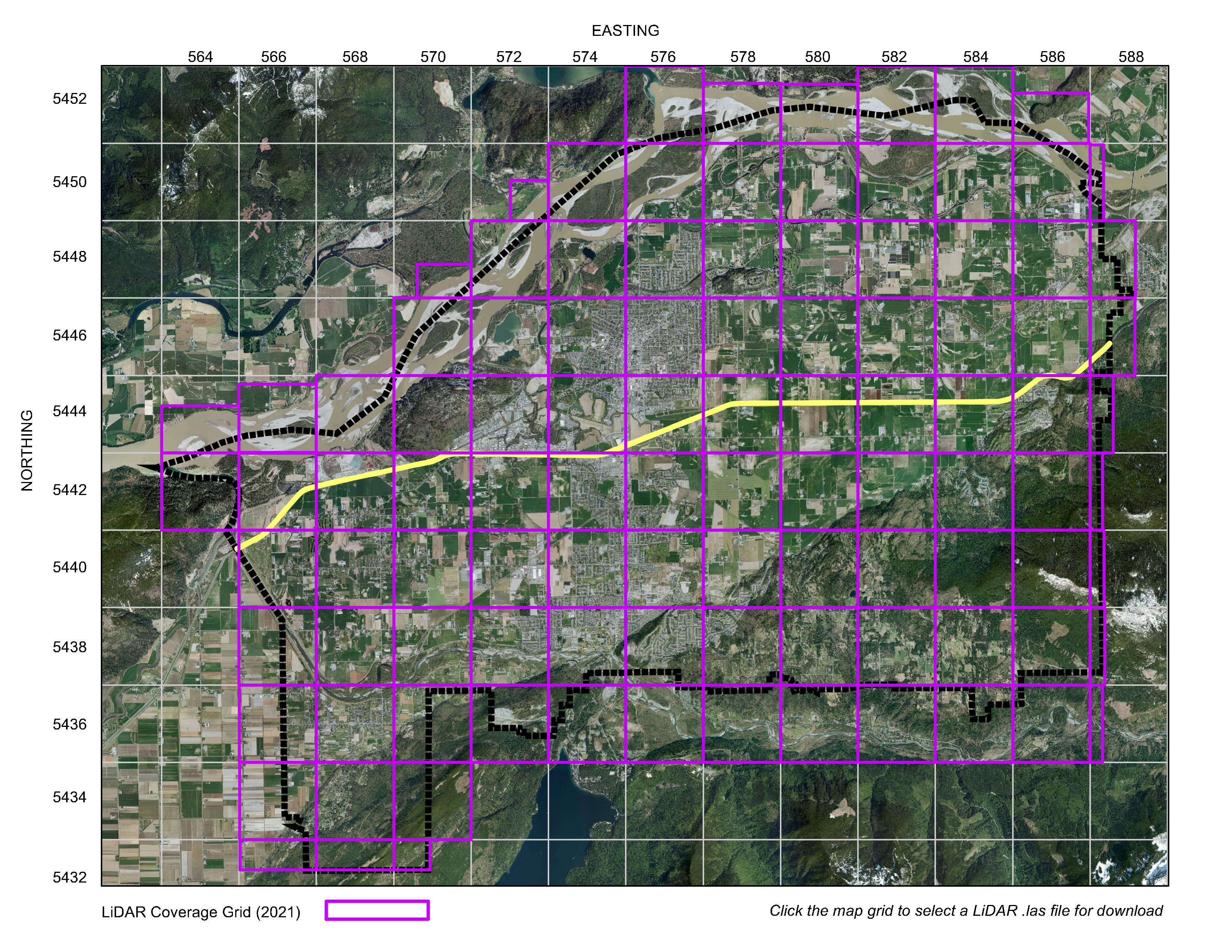
| LiDAR Bare Earth (2021) | |
|
Purpose: LiDAR Point Cloud Data (2021) - 'Bare Earth' Classification Abstract: LiDAR survey data was collected by McElhanney and Peregrine Aerial Surveys and reflects ground conditions as of Spring 2021 (LiDAR Flight Date: April 17 and May 15 2021). The data includes points classified as 'Bare Earth', with all other point features having been removed. The data can be downloaded by clicking the appropriate grid square in the LIDAR Index Map PDF. File Format: ASPRS LiDAR Data Exchange Format (LAS) version 1.4. LiDAR Sensor: Leica Terrain Mapper 2 (TM-2). Nominal Point Cloud Density: 10.2 pts/sqm Datum: NAD83 CSRS UTM Zone 10, CGVD28 HT2. Credits: Updated by the City of Chilliwack. Limitations: LIDAR data is not intended for construction or engineering purposes, and it is the responsibility of the user to ensure the accuracy of the data. |
The City takes no responsibility for the limitations of Google Earth, ERDAS ER Viewer or any other third party application.