Flood Protection
Within the City of Chilliwack, there are floodplain areas for both the Fraser River and Vedder River. Portions of Greendale and Yarrow lie within the floodplain for both rivers.
The flood risk associated with these two river systems is different, and therefore the City has separate Flood Response Plans to manage the risks. This webpage contains general information regarding flood protection and emergency preparedness for residents. For more specific information regarding the Fraser River or Vedder River, please visit these webpages:
|
|
Flood Hazard - What Does it Mean?
Flood hazard is often expressed in terms of the likelihood or probability of a given flood event occurring. For example, the 1894 flood on the Fraser River is the largest flood on record, and is estimated to be a "1 in 500 year" event. The provincial dike standard and floodplain mapping for the Fraser River is based on this event.
The expression "1 in 500" does not mean that this size of flood will only happen once every 500 years. For example, we can't say that because it happened in 1894, it won't happen again until close to the year 2400. Rather, it means that there is a 1 in 500 chance of it occurring in any given year (1/500 = 0.2% chance per year).
Similarly, the provincial dike standard and floodplain mapping for the Vedder River is based on the "1 in 200 year" event. This means that there is a 1/200 (0.5%) chance of it occurring in any given year.
This explains why we can hear about large flood events, for example "1 in 100 year" flood events, happening two years in a row; the "1 in 100 year" events have a 1/100 (1%) chance of happening in any given year.
Flood and Emergency Information for Residents:
Download and print an Emergency Preparedness basic kit checklist (Grab & Go Kit). There are a number of resources that you can access to be prepared in the event of a flood.
The following government websites provide information on flood and emergency preparedness: www.getprepared.gc.ca, PreparedBC, www.chilliwack.com/ep and www.fraserhealth.ca.
River Forecast Centre:
The Provincial River Forecast Centre collects and interprets snow, meteorological and streamflow data to provide warnings and forecasts of stream and lake runoff conditions around the province. Visit http://www.env.gov.bc.ca/rfc/ for current reports.
The City of Chilliwack uses the information provided by the River Forecast Centre when carrying out flood response activities.
General Flood Hazard Management:
Flood hazard management is accomplished through a variety of measures, including:
- Flood Protection Infrastructure
- Emergency Dike Upgrades Plan (identifies how to address priority areas for upgrading under emergency situations)
- Flood Response Plans for the Fraser River and Vedder River
- Flood construction levels and setbacks as specified in the Floodplain Regulation Bylaw
Regional / Intergovernmental Initiatives
Sumas River Watershed Flood Mitigation Planning Initiative
In April 2023 the City of Chilliwack signed the Sumas River Watershed Flood Mitigation Collaborative Framework, an agreement with the Province of BC, Semá:th, Mathxwí and Leq’á:mel First Nations and the City of Abbotsford to make Sumas Prairie more resilient to flooding.
This collaborative framework will support the design of mitigation projects in the Sumas River watershed and timely delivery of watershed recovery programs that best protect the people, farming community and infrastructure in this area from future flooding events.
Read more about the Sumas River Watershed Flood Mitigation Planning Initiative
Be Informed:
Due to variables such as weather, we cannot predict a flood with 100% certainty. Therefore, it is important that you make your plans on the assumption that flooding is a real possibility. The best thing for people to do is to review or establish personal and neighbourhood emergency plans and consider family members or friends who may need additional assistance. Please help those folks to be ready as well.
It is important to note that even if your home or business is located on higher ground, a serious flood event would result in a loss of key services like water, sewer, electricity and gas. In that case, a City-wide evacuation could occur. All residents should be prepared for at least a 72-hour period without services. We will provide as much information as possible to keep the public informed as waters start to rise.
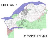
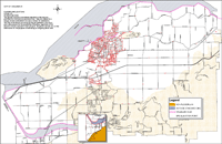
City of Chilliwack Floodplain/Elevation Maps:
| Do you live in the floodplain? Check this map to find out. |
What elevation is your home at? Check this map to find out. |
 |
 |
| Download Chilliwack Floodplain Map in PDF format with Road Names or without Road Names Updated version as of May 3, 2007 The floodplain is accurately shown on this map as based on the 2007 update. When the next mapping update is completed, it is not expected to significantly change the extent of the floodplain. |
Download Chilliwack Elevation Map in PDF format (8.77 MB) |
| Attachments | |||
| Description | Date | File Size | |
 |
Chilliwack Floodplain Map | 2011-12-28 | 287KB |
|
Chilliwack Floodplain Map (with Road Names) | 2011-12-28 | 430KB |
|
Floodplain Elevations | 2012-06-28 | 9.21MB |
|
Floodplain Maps Frequently Asked Questions | 2015-11-10 | 207KB |
Fraser River Flood Protection
Information and updates on the Fraser River Freshet and general flood protection information.
2023 Fraser River Freshet Information | Freshet FAQ’S (Frequently Asked Questions) | Flood History
Vedder River Flood Protection
Flood protection information for the Vedder River
Flood Evacuation Information
Preparing For An Evacuation: In flooding situations, residents in high risk areas should listen to the local media and follow the instructions of local emergency and transportation officials.
Flood Protection Infrastructure
Information regarding flood protection infrastructure